
Columbia River Gorge, Oregon Travel - Multnomah Falls and Up the Heights, Pt 2
See world famous Multnomah Falls, Wahkeena Falls, Fairy Falls & Horsetail Falls. This adventure will keep you in awe of nature, physically fit, and rejuvenated as you explore mountain wilderness heights, waterfalls & the stunning Columbia River Gorge. Pt 1 has Vista House, Latourell Falls & Bridal Veil Falls.
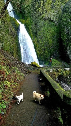
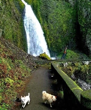
Wahkeena Falls
Location = Wahkeena Falls parking. From Portland, take Hwy I-84 east for about 27+ miles. Exit #28 Bridal Veil, at the end of the off-ramp turn left onto Old Historic Hwy. Drive 2.5 miles to parking on the left or right. The trail is on the right.
Option 1: Wahkeena Falls, Lemmons Viewpoint, Fairy Falls - 2 miles roundtrip. Elevation = about 960 feet.
Option 2: Option 1 and Wahkeena Springs - 3 miles roundtrip. Elevation = about 1,200 feet.
Option 3: Option 1-2 and Vista Point Trail 419 loop and Vista viewpoint - 3.6 miles roundtrip. Elevation = 1,565 feet.
Plan 4-7 days total for Parts 1-2. Best times to visit = late spring for flower blooms to late fall's gorgeous colors. Safety: A few trails are very narrow with sharp drop off's at higher elevations and very slippery when wet.
Don't miss: Vista House, Latourell Falls, Bridal Veil Falls, Pt 1.
Columbia River Gorge, Oregon
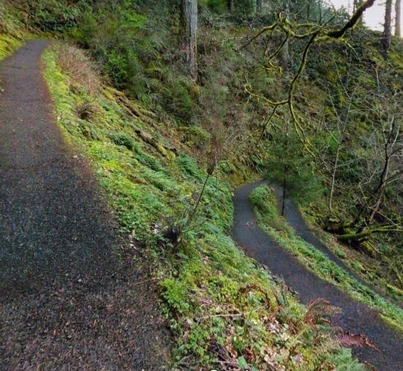
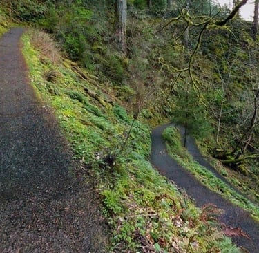
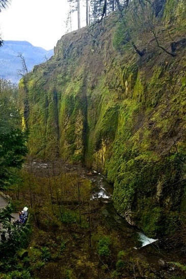
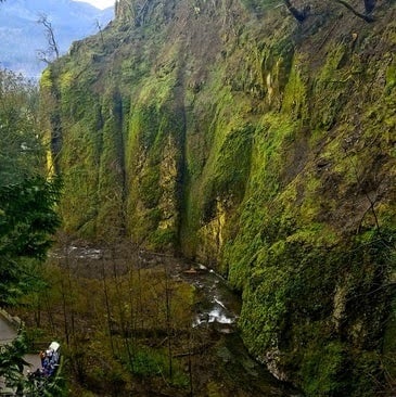
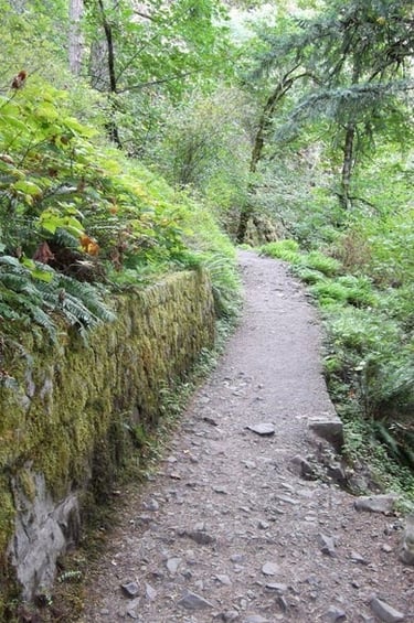
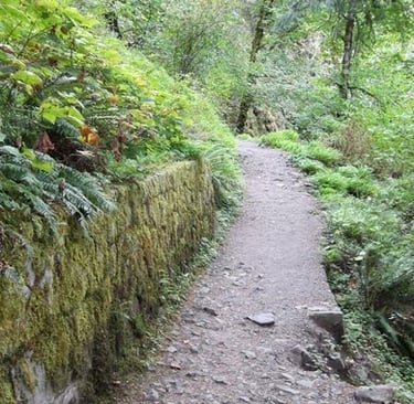
Lemmons Viewpoint - after the switchbacks you'll see a short side trail on the right. This is a good place to calm your heart rate, and enjoy the gorgeous views of the Columbia River Gorge. At this point, the paved trail ends.
Next up: Fairy Falls & Wahkeena Springs.
How about a cool down? When I'm exercising especially in warmer weather, I kinda glisten.... A LOT.... so a nice cool down before the sweat-fest starts is just what I need.
Alrighty then - time to get serious. We're heading up to Lemmons Viewpoint. If you start seeing stars, stop, inhale deeply, and slow your breathing down. Steady as she goes up thru 11 switchbacks.
It's about a 600 foot elevation gain in a 1/2 mile section, but the views get more impressive the higher you get. Still with me?
There are a few rather steep sections that occur in the switchback sections up to Wahkeena Springs. If you're fairly fit, you made need to rest a quick minute a couple times but your lungs should be able to handle the stretch. If you’re more the loungie-lizzy type - you may need an oxygen assist!
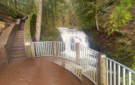
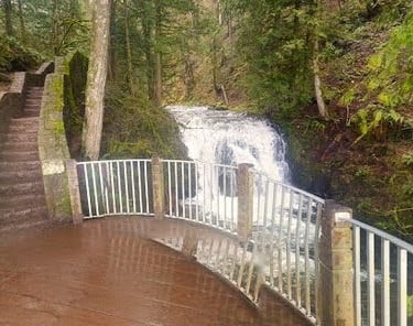
Just above the parking lot is a viewing platform - can you see all 242 feet of Wahkeena Falls in both tiers? Now take the trailhead on the right and head up the short distance to the stone bridge that's directly in front of the falls.
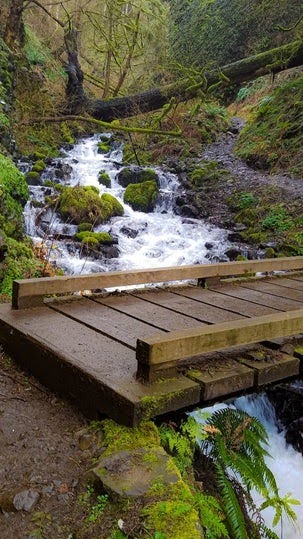
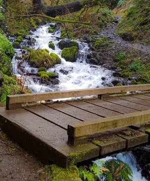
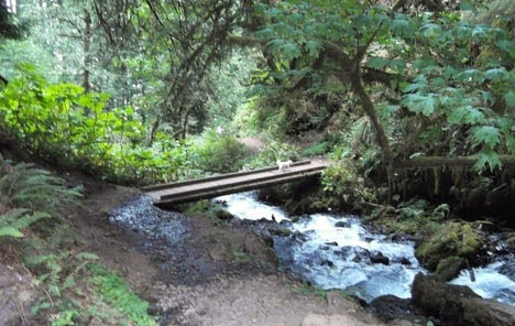
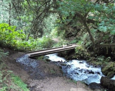
Location = Wahkeena Falls trail continues to Fairy Falls. From the Lemmons Viewpoint, you'll be crossing several footbridges to get to Fairy Falls. Next, enter a narrow passage with a huge rock on your right.
After crossing 2 more footbridges back and forth across the fast flowing Wahkeena Creek, you'll get to enjoy 6 more pretty steep switchbacks. (Yes, I know.... that was mean.... Sorry). After entering a canyon, you’ll arrive at Fairy Falls.
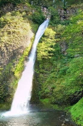
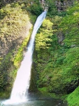
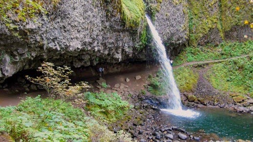
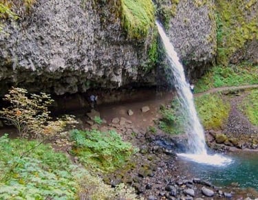
Fairy Falls is beautiful, fanning out into multiple streams of water and becoming thicker as they cascade over various rock outcroppings. These types of falls are more delicate & enchanting than the typical pony-tail style waterfall.
FYI: Hiking hack for feet: If you're feet are hot and tired then take your socks & shoes off - down wind of course, thanks. Then have a dip in the creek & wiggle your toes. Let them soak until they're cold. Cooling your feet will help them rejuvenate by reducing pain & inflammation. Cooler feet also helps cool your body down. Oh yeah, that felt great.
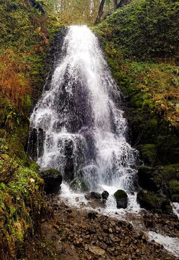
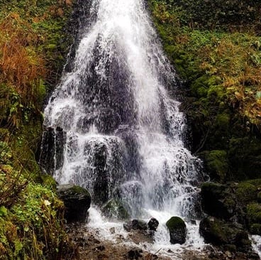
Fairy Falls
Next up: Wahkeena Springs. Continue up 5 switchbacks to Vista Point Trail #419. This is where you'll end up if you take the loop.
Stay on Wahkeena #420 to the right, and head up 3 switchbacks. After a short distance, take Angels Rest Trail #415 on the right.
You'll soon see the powerful Wahkeena Springs bursting out from the earth. It's worth seeing if you catch it spring to mid-summer.
Now go back to the main trail #420 and go right to begin the loop. After .3 mile, take Vista Point Trail #419 to the left. This is the highest elevation at 1,565 feet.
From here you'll be starting your descent down. Bet you liked hearing that.
Once on Vista Point Trail #419, go about 1/2 mile to a short, steep trail on the right for some Ah-mazing views. The views are the main reason for taking this loop. Next, continue on #419. The whole loop is only 1 mile. When you get to an intersection, go right on #420 and back down the 5 switcher-oos to Fairy Falls.
Whew that was a super awesome cardio and leg workout, but feels nice to be walking downhill. Every foot climbing up was still worth it, and we had a great time.... How about you? Now relax and enjoy a peaceful & gorgeous walk back down.
Location = M:ultnomah Falls Lodge. 53000 Historic River Hwy, Corbett OR. From Wahkeena Falls, continue 1/2 mile east on the Old Historic Highway to parking on the left. The Lodge is on the right with a coffee shop in case you need a caffeine jolt. You can also view the falls from the parking lot in the middle of Hwy I-84 Highway or the lot off the Old Historic Hwy. FYI: Multnomah Falls parking areas require a “Timed Use Permit” from May 24 thru Sept. 2, 2024.You
* Win a Price = Be the 1st to find Benny, my little fur-baby in 2 photos in this Blog.
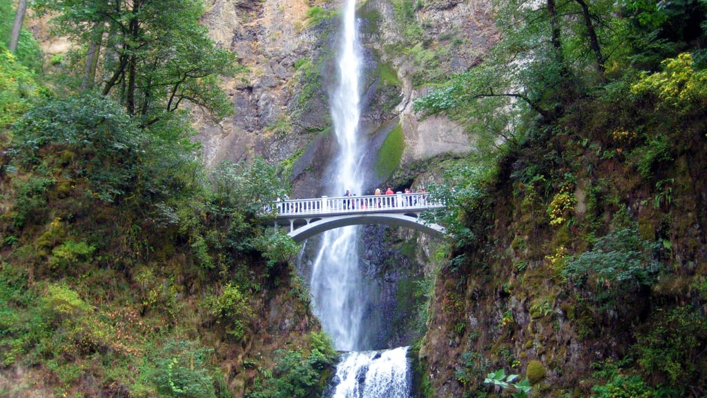
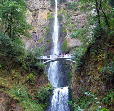
The trail to Multnomah Falls is actually the Larch Mountain Trail #441 is 2.4 miles roundtrip with a 870 feet elevation gain. It's the tallest waterfall in Oregon at 620 feet. Walk the .25 mile trail to Benson Bridge to get an up close view of the lower falls. This is where you can literally see, feel, smell, taste, and hear the raw power of the falls. Stand there for a minute and soak up the spray..... yep, even drenched you're looking gorgeous!
From Benson Bridge to the top of the Multnomah Falls is a moderate climb. However, be warned there's 11 switchbacks. At the 1st switchback, stay right otherwise you'll end up on Trail #400. As you approach switchback #4, stay quiet and walk softly - you might get lucky and see some little Pika's scurrying about.
After the switchbacks, the trail splits into a "Y" intersection - stay right to get to the top of Multnomah Falls. It's really an incredible vantage point. Follow the paved path down a few sets of stairs to a patio which is literally on the very edge. If your vertigo can handle it, look down..... ALL the way down. Oh good Lord..... I got dizzy on that one. I wanted to soak in the wonder, so I forced myself to try again.
NOPE - couldn't look down long enough to take a photo, or focus on anything. It's a struggle for me to push past my fear of heights. But, I love this hike and the creek that runs alongside the trail. If you don't do any of the other hikes in this blog - do this one. It's gorgeous, serene and invigorating.
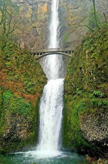
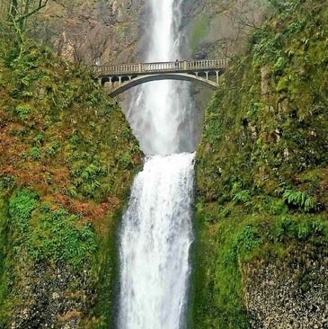
Benson Bridge was built in 1914 and is one of the most recognized & photographed waterfalls around the world.
It draws over 2 million visitors per year. All 5 of your senses can experience Multnomah Falls as it thunders it's way down.
Don’t forget to look up & down to capture the whole magnificence of this waterfall.
You'll feel ant-sized compared to it's enormous-ness.
Multnomah Falls
Option: 3 more waterfalls up ahead. Since we'd been hitting the uphill trails pretty hard, and still had another day of uphill exploring, we decided to head back. In hind sight - we should've kept going.
With an easy hike about 130 feet higher up, and less than .4 mile - you can see some pretty amazing waterfalls: Dutchman Falls which are fairly short in height and Weisendanger Falls and Ecola Falls are both around 55 feet high. Ecola is more unique because there's a 2nd waterfall behind the tallest waterfall in front. Some people call it the Double Falls. These would have been nice to see.
Location = Horsetail Falls parking. From Multnomah Falls, go east on Old Historic Hwy about 2.5 miles, parking is on the left. From Portland, take I-84, then Exit 35 to Ainsworth. On the off ramp curve to the right, then left on Old Historic Hwy. After 1.2 miles, parking is on the right.
FYI: there are steep cliffs & narrow trails in spots - use caution especially if it's wet.
From the street, you can see the 216 foot Horsetail Falls measured by Multnomah County's waterfall survey, but claimed by many to be 176 feet. The falls plummet into a pool at the bottom.
Personally, I think waterfall pool wading is an awesome experience - and one of my happy jams. Lucky for all - no sweating up switchbacks, just walk across the street and enjoy Horsetail Falls.
Horsetail Falls
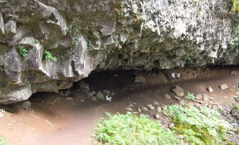
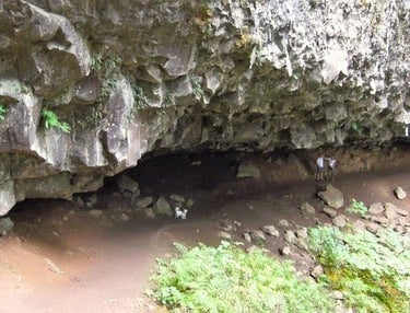
Ponytail Falls
My little guy Benny (my dog) loves exploring as much as I do. He has such a great time, can you see him down below under the overhang? Checkout the stunning blue-green colors of the pool at the bottom of Ponytail Falls. To continue to the Overlook viewpoint, continue for about .3 mile to the first short trail to the right. That's it, super easy. The Overlook trail is actually a little loop, so take it around and go left back on Horsetail Falls #438 to return.
Note: we chose not to continue because the trail ends at the Old Historic Highway - narrow with no sidewalks. With a 1/2 mile hike back to parking and 3 small dogs, we couldn't take the chance.
Location = Ponytail Falls is in the same location as Horsetail Falls. The trail to Ponytail Falls is .8 mile roundtrip. Looking at Horsetail Falls, walk left to Horsetail Falls Trail #438. We also added on about .6 mile roundtrip to an Overlook with a nice view of the Columbia River Gorge.
The trail to Ponytail Falls barely gets going before it jumps into 2 fairly easy switchbacks. Go past the Trail #400 on the left, and keep to the right. Then head up 4 more switchbacks.
From here, the travel levels out. Keep singing along until you suddenly find yourself in a narrow little gorge. You'll notice it get's pretty quiet except for the faint roar of Ponytail Falls.
When you get to the trail split, stay right again. Within minutes you'll see a major rock formation. Follow the trail under the massive overhanging rock for another amazing viewpoint from behind the falls.
Location = Historical Museum at Cascade Locks, Oregon. 417 SW Portage Rd, Cascade Locks, OR.
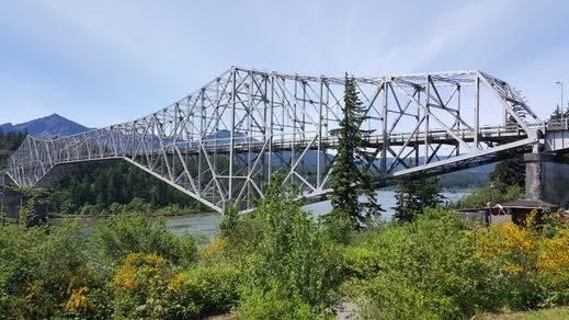
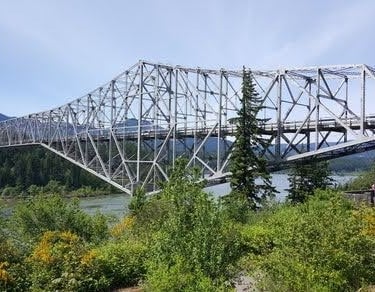
Cascade Locks is a quaint, little blip on the map in the Columbia River Gorge that offers several things to do in a more relaxed pace. It's a nice break for 1-2 hours if you've been hoofin' it uphill for a few days! From Cascade Locks you can see the "Bridge of the Gods" to the west, which takes you across the border (the Columbia River) into Washington.
Several interesting little treasures can be found at the Marine Park along the Columbia River.
Historical Museum - small entry fee. Learn about Native Americans & early settlers in the area, as well as info about the Bridge of the Gods and the locks. The Museum also has several events throughout the year.
Oregon Pony - the first steam locomotive that started carrying steamboat passengers & cargo in 1862.
Sternwheeler - This was my favorite, a cruise on the 3 story paddle-wheeler. You'll learn the interesting story of Lewis & Clark's expedition (1803-1806) from Pennsylvania to Astoria, Oregon. See my Blog: Astoria, Oregon Coast Pt 3. Interesting tidbit: the first name of courageous explorer Mr. Lewis (of Lewis & Clark) - was Meriwether.
The statue of Princess Sacagawea - the first Indian guide for Lewis & Clark in 1806.
Playground at the Marine Park Pavilion for all the kiddos. And disc golf for the big kids.
There's also fishing, sailing, camping, a marina, boat launch, and a beach for you to enjoy.
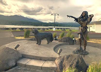
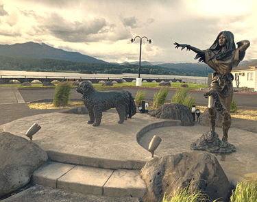
Cascade Locks
More Fun Things to Do
Columbia River Gorge - in this 80+ mile stretch of wilderness, there are 108 named waterfalls + 13 state parks.
Eagle Creek Trail - There's 8 waterfalls within 5 miles on this trail. You won't wanna miss Punchbowl Falls.
Williker's Toy Shoppe – a wonderland for kids of all sizes in the Columbia Gorge Hotel & Spa, Hood River OR.
Horseback riding - there are a few stables in Hood River OR.
Golfing - there's a golf course in Hood River OR and 2 courses in Carson WA and 1 in Stevenson WA. You
Great add-on trip - See my Blog: Troll Patrol, Witch's Castle & Zoo Alien in Portland.
Vacation Travel Tips
Average temps high/low = Summer 76/52 degrees F. Winter 44/30. Expect some light rain/drizzle during summer. Winters often get heavy snowfall the further east you travel. The gorge is typically windy - great for water sports. In winter, the winds can add a real chill.
Backpack essentials - water, bug spray, sunscreen, whistle, flashlight, cell phone, pocket knife, camera, and a light jacket for summer.
Winter Essentials - thermal blanket, waterproof hiking boots, and extra warm clothing.
Hiking conditions - trails can be wet & slippery even in summer. Expect 2+ feet of snow in some lower elevations.
Vehicle safety – Keep a spare blanket, boots, jacket, gloves, and snacks in the car. Winter roads can be icy & covered in snow - use “winter” tires. FYI: If you have "all season" tires, take snow chains.
Wild animals - rarely seen on trails, but they're out there.
Trash - Pack out what you pack in.
Rivers/lakes – river shoes are a must. Heavy winter rains/snow means ice-cold, deep, & fast moving water.
Poison Oak - it grows as a vine or a shrub, and has 3 or more leaves/group.
Rattlesnakes - Prefer dry/warm areas, not usually found above 6,000 ft.
Wilderness areas – take a buddy & tell someone your travel plans.

