Columbia River Gorge, Oregon Travel - Multnomah Falls and Up the Heights, Pt 1
This adventure will keep you in awe of nature, physically fit, and rejuvenated as you explore mountain wilderness heights, waterfalls & the stunning scenery of Columbia River Gorge. See Vista House, Latourell Falls & Bridal Veil Falls. More in Pt 2 like world famous Multnomah Falls. A bucket list add.
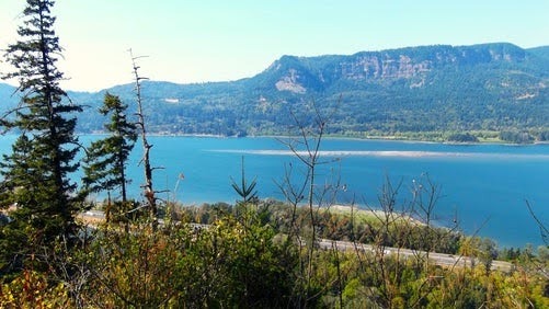
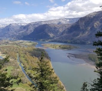
Location = The Columbia River Gorge begins east of Portland on I-84 East. The gorge follows the Columbia River and starts at Sandy River/Columbia River intersection and continues about 80+ miles to Deschutes River/Columbia River intersection. The Columbia River is the border between Oregon & Washington. It begins in Canada and meanders 1,243 miles until it empties into the Pacific Ocean.
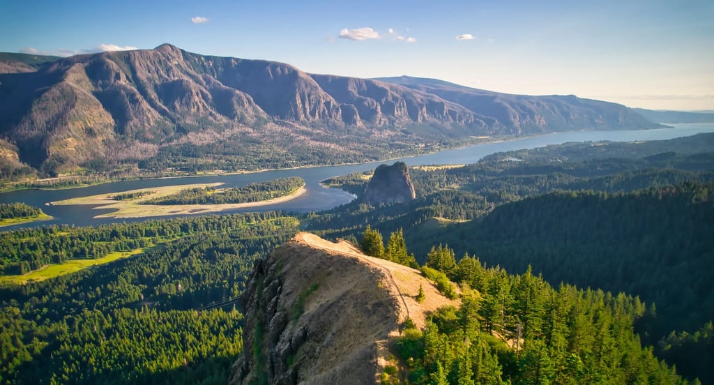
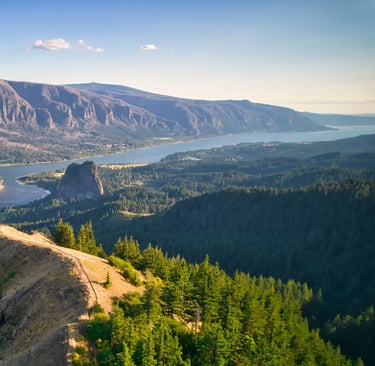
From sea level, the Columbia River Gorge canyon walls soar up to heights of 4,000 feet. Photo up top: the mountains at the top of the photo are in Washington, and the forested mountains below are in Oregon.
The gorge makes up the largest national scenic area designated in the USA - with 13 State parks + 108 named waterfalls. The scenery is majestic and breathtaking. Imagine the extreme difficulties that early pioneers faced in 1792 as they tried to navigate up river from the Pacific Ocean, or build anything up the cliffs. FYI: If you're looking to swim in the Columbia River - be cautious because it's a powerful force most of the year.
Plan 4-7 days total for Parts 1-2. Best times to visit = late spring for flower blooms to late fall's gorgeous colors. Safety: A few trails are very narrow with sharp drop off's at higher elevations and very slippery when wet.
Don't miss: Famous Multnomah Falls, Columbia River Gorge in Pt 2.
Columbia River Gorge, Oregon
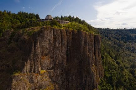
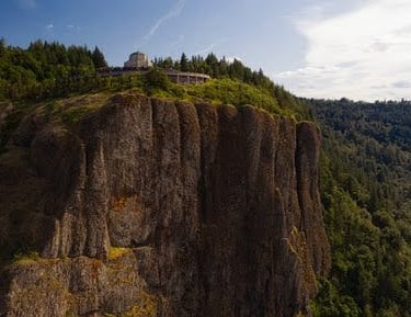
Location = Vista House. 40700 Old Historic Columbia River Hwy, Corbett OR. From the Sandy River bridge in Troutdale, on the I-84 to Vista House is about 8.4 miles. FYI: Vista House, open hours for inside access.
The Vista House is perched 733 feet up the cliff, and built in 1917 after German style architecture. The dome ceiling on the inside is 55 feet high, and made from marble imported from Alaska. The fountain outside was hand-carved. Its original purpose was two-fold: to commemorate the hardships of early pioneers and to provide a rest stop for weary travelers along the Old Historic Highway, which is usually much higher than Hwy I-84.
The first wagon road was narrow, and steep with 20% grades, constructed in 1870. Finally in 1913 construction began on the Old Historic Highway, a portion of which is named US 30. This was the first highway to be paved in Oregon and took 9 years to complete 75 miles. It also included horseshoe curves to avoid steep grades along the hillside. It's purpose was to bring travelers alongside the scenic beauty & natural wonders of the Columbia River Gorge.
The views from the Vista House are spectacular and from this height, you'll feel as small as a grasshopper as you take in the 360 degrees views of the enormity & beauty of God’s creation. Ponder reaching this height on horseback or wagon.
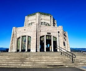


Vista House
Location = Latourell Falls parking lot. From Vista House, continue east on the Old Historic Highway for 2.5 miles to a parking lot on the right. Overflow parking = head back west over the bridge, 1/10 mile on the right.
Latourell Falls is about 2 miles roundtrip loop to see both upper & lower falls with a 750 elevation gain. It's easier to hike up to the upper falls first, to even out the elevation gains. It's considered moderate and rocky with a few steep spots.
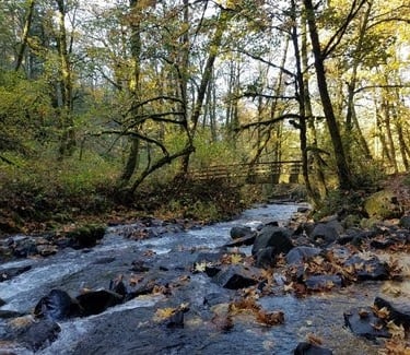
From the parking lot, start on the trail to the left. The loop will bring you back on the trail to the right. After the switchbacks & winding around a "U" curve, you'll see a trail off to the right. It just goes across the creek to the backside of our loop, so stay on the main trail.
Go thru a few more little switchbacks & 4 little bridges back & forth across Latourell Creek. CAREFUL - use your super traction powers thru the steep drop offs. It was wet when we were there, so definitely a little scary.
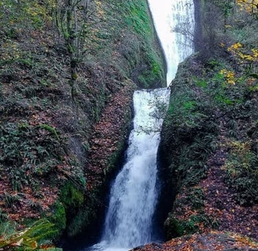
At the upper Latourell Falls you can get really close..... and if you like, really wet. The cool spray feels great because it's a hot one today. After mid-summer, the falls might be less dramatic until after the winter rains.
Pssst..... you gotta walk behind the falls. It's one of my FAVE things to do besides swimming in the pools. I think standing behind the falls provides more of an enchanting viewpoint. Don’t forget to take in the magnificent panorama of the gorge below.
To head back, cross the creek again and soon make a sharp right and "U" turn around to the left. Then go past 2 short trails on the right, and meander down and under the Hwy. Take the next right to stay on Latourell Falls trail and then back under the Hwy.
You're almost at the lower falls.... and by now, you should be able to hear the falls roaring in the distance.
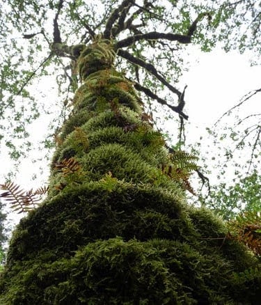
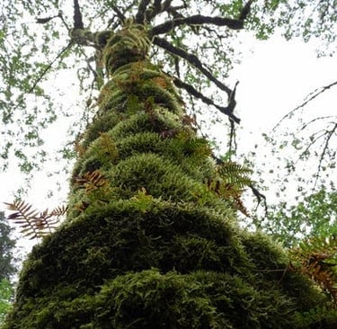
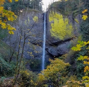
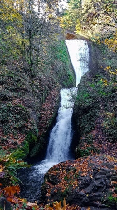
Latourell Falls is an impressive 224 foot drop, cascading down a massive boulder that's spotted with almost neon yellow-green moss. Personally, I think the moss adds to it's beauty.
What do you think? Let me know if you have another favorite Columbia River Gorge waterfall.
If you have dogs, the creek makes a great watering hole. Well.... you're almost back to the parking lot. Hope you enjoyed another gorgeous waterfall hike.
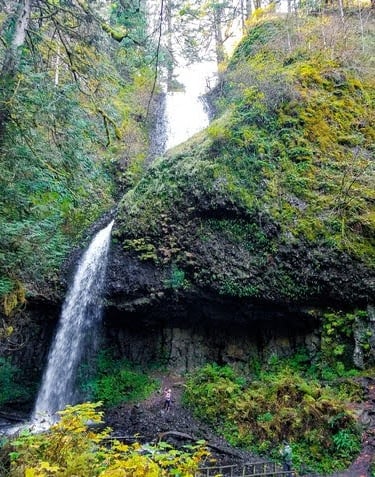
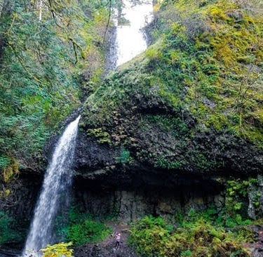
Latourell Falls
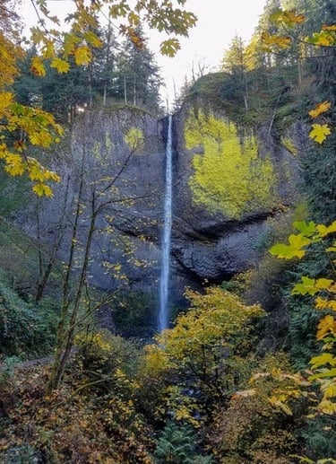
Location = Bridal Veil Falls parking lot. 46650 Historic Columbia River Hwy, Corbett, OR. From Latourell Falls on the Old Hwy, Bridal Veil is about 2.1 miles further east with parking on the left.
Bridal Veil Falls Trail is about .6 mile roundtrip with the option to head down a steep incline to the base of the falls. To get to Bridal Veil Falls, take the trail to the far right off the parking lot by the restrooms. Cross the bridge over the creek, stay right, and then climb the stairs up to the viewpoint.
It’s a nice 120 foot plunge which flows down & under the old 1914 bridge. State Park's warning - do not walk along that bridge to see the falls as it's too narrow and no room for pedestrians. * Win a prize = Be the 1st person to tell us why this should be called Hearts Waterfall? The answer is at Bridal Veil Falls.
Option: Back at the footbridge, go right along the wall, past a gate. Circle to the left thru blackberry bushes to the water cistern believed to be part of the old Lumber Mill. The 10’x10’ shed was converted into a Post Office in 1887 and it's the 2nd smallest USA Post Office. It's still used today to mail wedding invites.
The Bridal Veil Mill closed in 1988 - and the town of Bridal Veil vanished.
Head back to the parking lot, and take the trail that was left of the restrooms. It's worth your time.
The Overlook Loop Trail is 1/2 mile that travels along a rim above the beautiful Columbia River. The views are amazing.
You'll also get a chance to view Bridal Veil Falls again. Be aware - there's poison oak in a couple places.


Bridal Veil Falls
Vacation Travel Tips
Average temps high/low = Summer 76/52 degrees F. Winter 44/30. Expect some light rain/drizzle during summer. Winters often get heavy snowfall the further east you travel. The gorge is typically windy - great for water sports. In winter, the winds can add a real chill.
Backpack essentials - water, bug spray, sunscreen, whistle, flashlight, cell phone, pocket knife, camera, and a light jacket for summer.
Winter Essentials - thermal blanket, waterproof hiking boots, and extra warm clothing.
Hiking conditions - trails can be wet & slippery even in summer. Expect 2+ feet of snow in some lower elevations.
Vehicle safety – Keep a spare blanket, boots, jacket, gloves, and snacks in the car. Winter roads can be icy & covered in snow - use “winter” tires. FYI: If you have "all season" tires, take snow chains.
Wild animals - rarely seen on trails, but they're out there.
Trash - Pack out what you pack in.
Rivers/lakes – river shoes are a must. Heavy winter rains/snow means ice-cold, deep, & fast moving water.
Poison Oak - it grows as a vine or a shrub, and has 3 or more leaves/group.
Rattlesnakes - Prefer dry/warm areas, not usually found above 6,000 ft.
Wilderness areas – take a buddy & tell someone your travel plans.