
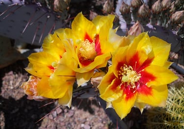
Cliff Dwellings & Rock Waterslide - Sedona, AZ
Explore Indian cliff dwellings at Montezuma's Castle. Hike the trails at red rock giants like Bell Rock, Courthouse Butte & Cathedral Rock. See Chapel of the Holy Cross & Palatki's Heritage cliff dwellings. Ride the rock waterslide at Slide Rock Park and explore Sedona's canyons & swim holes.
Cliff Dwellings & Rock Waterslide
Table of Contents
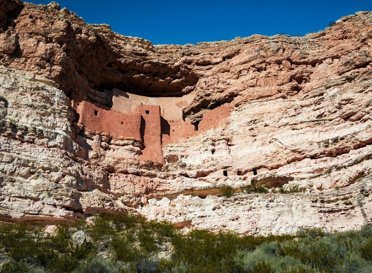
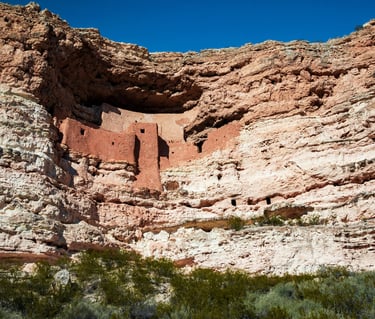
Location = Montezuma Castle. 2800 Montezuma Castle Rd, Camp Verde, AZ - south of Sedona. Open 9 am - 4:45 pm daily, except for Thanksgiving day, Christmas day, and January 1st. Small entry fee.
The first permanent Sinagua dwellings were pit houses, dug partially underground and then covered, possibly built as early as 650 A.D.. Sinagua is a Spanish word meaning sin agua = without water. "Without water" doesn't actually apply here, with Beaver Creek & Montezuma's Well up the road. The mountain peaks north of Flagstaff were called Sierra Sin Agua by Spanish explorers, so the name Sinagua was given to the tribe after being discovered in the area in 1939.
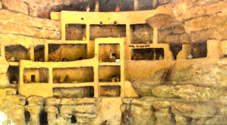
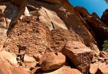
After pit houses came the pueblos or cliff dwellings - built in natural caves which often had ladders to access the upper levels. These first cliff dwellings at Montezuma Castle Monument were built by the Sinagua around 1,050 AD. Montezuma Castle is a 20 room structure that housed several families.
Built high in the rock cliffs offered protection from severe weather and protection from unwanted intruders whether animal or people. The downside - it's a heck of a climb, up and down, to fetch water and gather or hunt for food. And, it must have been quite the exercise in strength & willpower to haul up any big game. If I was the chief's wife - I would have contracted for a stairway in stone!
Around 1425 AD, the Sinagua migrated to other areas. Some say that not all left but joined other tribes in Arizona, like the Yavapai, Apache, Hopi, or Zuni.
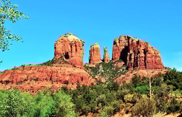
Montezuma Castle Monument
Montezuma's Well
Location = 5512 County Rd 77, Rimrock, AZ. Montezuma's Well is a huge sinkhole and natural spring. The historic Back Ranch house is also here. Mr. Back bought the land around the Well in 1889. The Well receives about 13 inches of rainwater/year. In addition to rainwater - every day, 1.5 million gallons of underground water pushes it's way up to the surface.
Be warned though - the water in Montezuma's Well is toxic. It's loaded with arsenic and carbon dioxide and fish can't even survive. However, there's 5 different organisms that supposedly only live in this Well, and can somehow survive - including a water scorpion & leeches. Uh.... GROSS.
Remnants of the earliest Sinagua homes called pit houses can be seen partially underground near the Well.
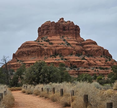
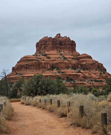
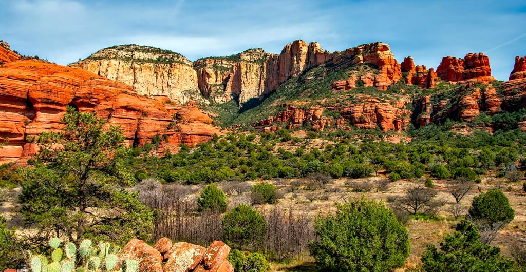
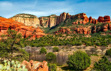
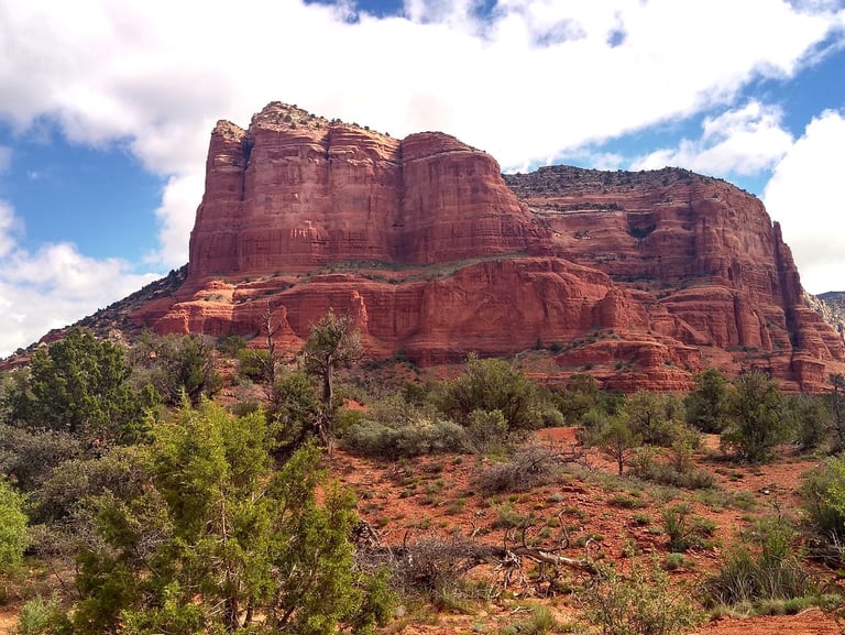
Location = No address to Bell Rock, Sedona. Take Forest Service Rd off Hwy 179 to Courthouse Vista parking. See Parking Pass info above. Mountain bikes use this crowded trail, so maybe arrive early or after 2 pm. Carry EXTRA water as shade is almost non-existent. Maybe hit the restrooms first?
The loop trail is 4 miles to view both these iconic rock formations: Bell Rock, photo right & Courthouse Butte below. From the parking lot, follow the sign to Bell Rock Path. Once at the intersection, stop and take a mental image so you don't miss the Access trail back to your car.
Also from here you could go straight to climb Bell Rock. After reading some reviews - I opted out due to my fear of heights. I love climbing UP.... just wish I could catch a tram DOWN. Seriously, that would be awesome.
Go left on Bell Rock Path - heading into a clockwise loop to the right & back to this spot. Follow the mounds of stone wrapped in wire mesh, and keep the ginormous Courthouse Butte always on your right.
Go right on Llama Trail for a short way & right on Courthouse Butte Loop. As you head towards the back side of Courthouse Butte, you'll head thru some trees & desert plants and come to a fork. Go right.
Next, cross a narrow wash bed which I'm told can have a decent water flow in winter & early summer. In September, we took our shoes off and our toes enjoyed wiggling in the shallow waters. At the end of the creek, follow the sign to Big Park Loop to the right.

Parking Fees: $5 per day for any Sedona trails. Buy passes at trailheads, Visitor's Center, Ranger Stations, or at local hotels/businesses.
FYI: Highway 179 is the Redrock Scenic Byway, and includes Red Rock State Park.
It get's a little confusing on the ground, so just follow the trail that's closest to Courthouse Butte. After a short distance, stay on Big Park Loop straight ahead. You'll see the first of 3 trails that branch off to the left. As you arrive at the back side of Courthouse Butte, you'll emerge into a huge field of tall grasses. From here, the fairly level dome stands proudly to your right.
Eventually, Bell Rock will appear behind Courthouse Butte. At the intersection, go right on Bell Rock Path. After passing Bell Rock, you'll soon see a trail to the left - take the 2nd one - which is the Access trail back to the parking lot. The color palette is gorgeous - miles of green trees sprinkled around towering red rock formations, covered by blue skies. Despite other hikers around - it was both a beautiful and serene journey.
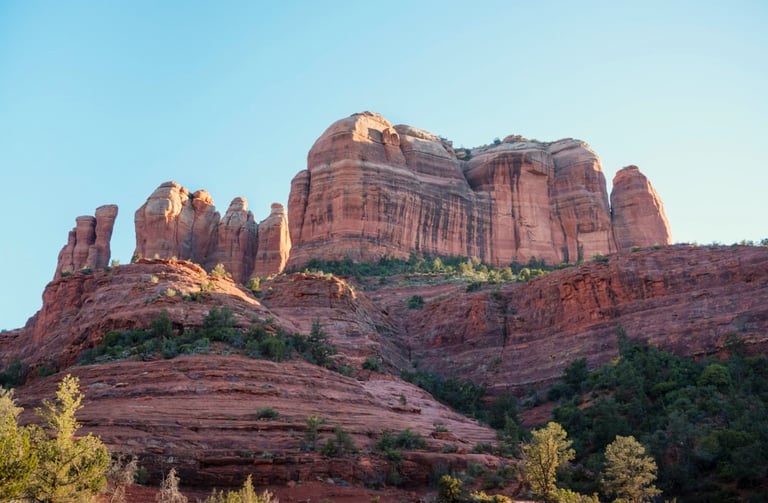
Bell Rock & Courthouse Butte Trail
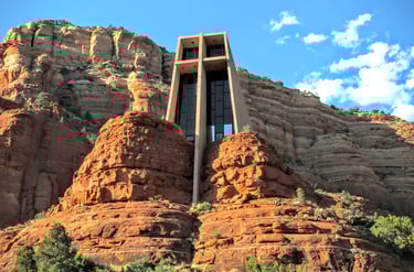
Location = Holy Cross Chapel. 780 Chapel Rd, Sedona. Open 9-5, Mon-Sun. Restrooms are down the hill. The site attracts crowds and parking is limited, so go earlier or later in the day during peak seasons.
Chapel of the Holy Cross is a Roman Catholic church which still holds services. The cross is much more stunning on the inside.
Marguerite, a Sedona local, commissioned the Chapel to be built. Her first attempt was in Budapest, Hungary with Lloyd Wright, the son of famous architect Frank Lloyd Wright. The project failed due to the start of World War II.
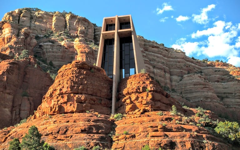
Refusing to give up, Marguerite began construction in Sedona. Finally, in 1956 she saw her vision completed for a total of $300,000. The stained glass window in front is literally held together by Christ on the giant 90 foot high cross. FYI: Don't miss the Chapel of the Holy Cross at night - photo at the bottom. The night sky appears like a dark, thick blanket covered in twinkly lights and draped below the heavens. I'll bet nights with a full moon are beautifully magical.
Chapel of the Holy Cross
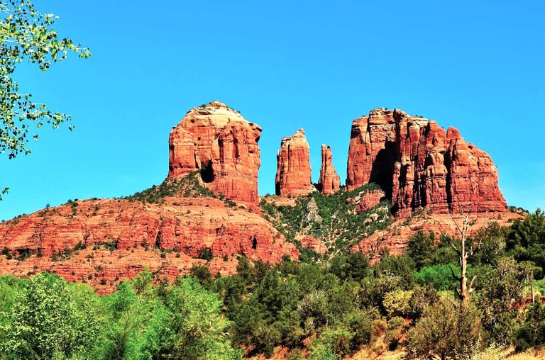
Location = Cathedral Rock. 500 Back O Beyond Rd, Sedona.
Cathedral Rock is about 1.4 miles roundtrip if you climb to the top. However, further research revealed that half of that is a steep & strenuous incline, but then I started thinking....
The decline would be just as steep - but more perilous with high odds of sliding to my death. That's a paralyzing image - so I'll pass. If I had a rope to hold onto, I could go down backwards and not have my fear of heights in full panic mode.
If you're lucky not to have a fear of heights - I'd love to see your photos of those spectacular views.
Cathedral Rock is really crowded during peak season, likely due to the thrill of the climb, the unbelievable views, and the vortex. A friend of mine loves to climb for the sunset views. Remember - when darkness comes.... it's a total blackout, so don't get lost.
There's 6 trails around the Cathedral Rock area. Even if you can't get photos from a bird's eye view - shots from ground level are still spectacular.
After parking, take Cathedral Rock trail. At the intersection go left on Templeton trail. The best ground photos are within the first 1.5 miles or so, making it a 3 mile roundtrip.
I've climbed plenty of mountains and usually prefer the uphill route. Plus my knee isn't happy about the long, downhill hikes. Climbers: get hiking boots for traction & some safety gear like rope, flashlight, whistle, fully charged phone, thermal blanket for cold/wind/rain under 1 pound, trail snacks & extra water. Use a backpack with front strap around the waist to secure it while climbing. Not to sound like anyone's mom - but, you never know... better safe than sorry.
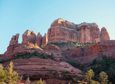
Cathedral Rock Trail
Location = Palatki Heritage Site. 10290 N. 795, Sedona. From Hwy 89a, go 7.8 miles on Forest Rd 525 to parking.
FYI: requires a $5/day Sedona Red Rock vehicle pass online. Reserve your 1 hour guided tour online only. Forest Rd is not paved & bumpy - cars low to the ground will have trouble. NO pets allowed - not even in cars. The 60 steps to the site are moderate.
Palatki Heritage Site was first documented by the Smithsonian Institute in 1895. They called it Palatki, and it's sister site Honanki. Palatki means "red house" In the Hopi Indian language.
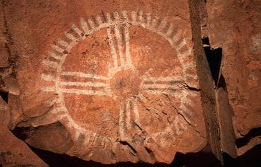
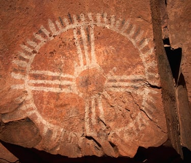
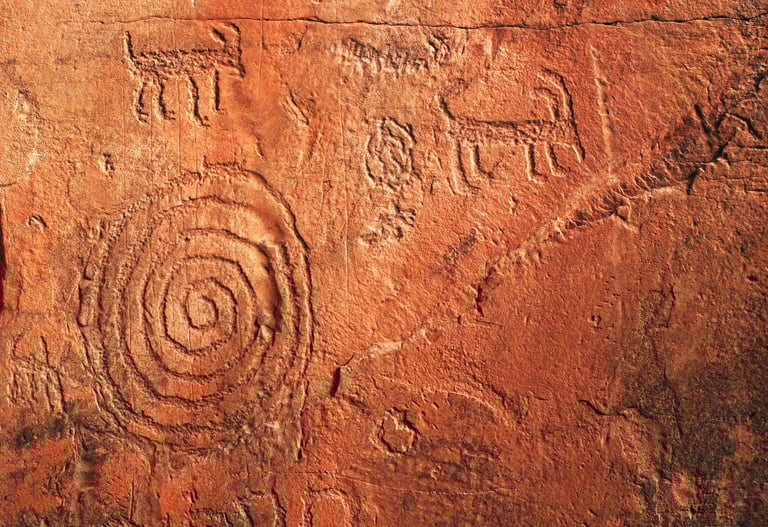
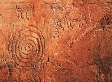
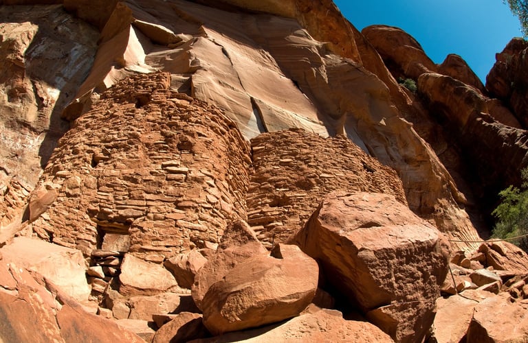
The trails to the Palatki cliff dwellings are both 1/2 mile roundtrip. You'll see almost 900 year old petroglyphs, a type of rock art, and pictographs, a symbol for a word or phrase. These Sinagua cliff dwellings were built around 1125 AD and were occupied until around 1300 AD. The dwelling available to view has 5 rooms on the bottom floor with 3 more upstairs. The trail climbs slowly until you get to the stone steps that take you up to the cliff dwellings.
Palatki Heritage Site
The trail to the petroglyphs is an easy climb along the cliff, and up the stone steps to a cliff overhang. You'll learn some interesting facts: like the drawings were originally painted in white, but soot from the fire caused the animal fat that's used to make the paint to change color. Animal fat? How long did it take to figure that one out?
The Palatki Heritage Site has cave walls covered in cave drawings & symbols which must have taken forever to create. No one knows exactly why the Sinagua disappeared - environment, conflict, overpopulation, or some other reason. Also around the area - you can find grinding stones, discarded corn cobs (which I can't believe survived over time), and pottery shards. It's astonishing, you're looking at 800-900 year old stuff made with a rock tool - not even a hammer & chisel.
Location = Slide Rock Park. 6871 N. Highway 89A, Sedona. Fees: $10 to $30 per vehicle depending on the date, and hours vary during the year. It's crowded in peak seasons. The Park has a gift shop & small store.
FYI: Slide Rock Park is first come, first served to control crowds. NO pets allowed - not even in vehicles. No glass - they check coolers.
Beware of Javelinas - small boars able to inflict serious, crippling bites, and hang around the main picnic area near the parking lot.
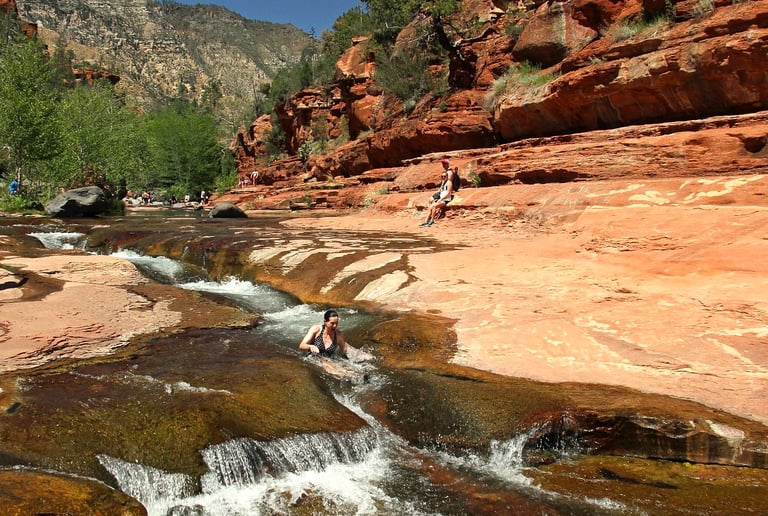
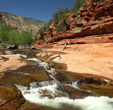
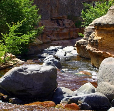
Slide Rock is 2.5 to 4 feet wide, and 80 feet long per the Park. The swimming area is 1/2 mile long in Oak Creek. We saw a few people using a tube and it looked like a super fun ride. To protect my feet - I always wear river shoes and they help a bit with traction.
Woo-hoo your way thru the slip-and-slide ride as many times as you want. Then relax, dry out, and warm your bones on the fairly flat rock ledges. Ready for a repeat? Round 2 of the rock waterslide is up next.... and then lunch.
FYI: The creek bed & rocks underwater are covered in algae making them really slippery and I've heard of many injuries.
Slide Rock Park originally began when Mr. Pendley bought the land in 1910, and successfully created an irrigation system that's still used today. That allowed him to plant his apple orchard which is still producing today. Once the canyon road was built in 1914 and news of the main roadway would be paved - he constructed cabins to host tourists. If you love history - check out the old homestead & cabins. If you want to pick apples - check with the Park or go to their Apple Festival in October.
Slide Rock State Park
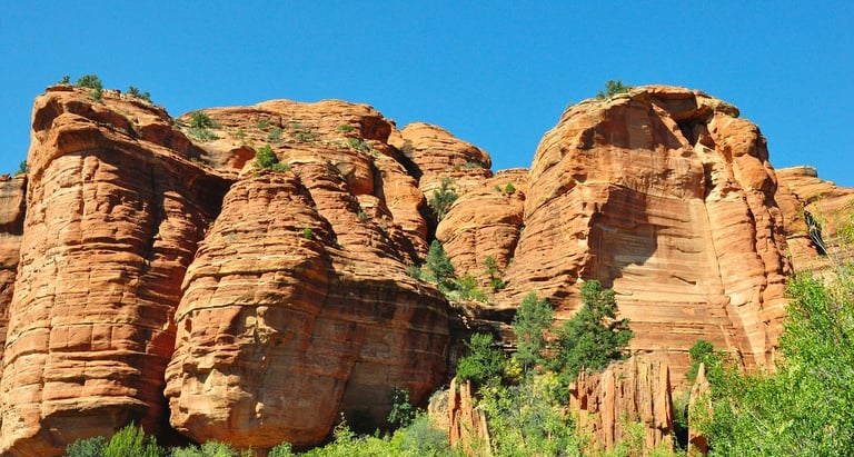
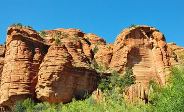
Sedona is Red Rock Country
Sedona AZ is known as red rock country. It's covered in stunning iron-oxide (red) sandstone rocks with layers of dazzling quartz crystals. The rocks come in various formations from pillars to other massive shapes. It truly has unique beauty.
There's also multiple locations of energy centers called a vortex. They say the electromagnetic energy has healing properties. These vortexes has turned Sedona into a spiritual destination, drawing people worldwide. Native American tribes also call Sedona a sacred place & the land of their spiritual beginnings.
More Fun Things to Do - Sedona
Best times to visit are March to mid-Jun and Sept to mid-Dec.
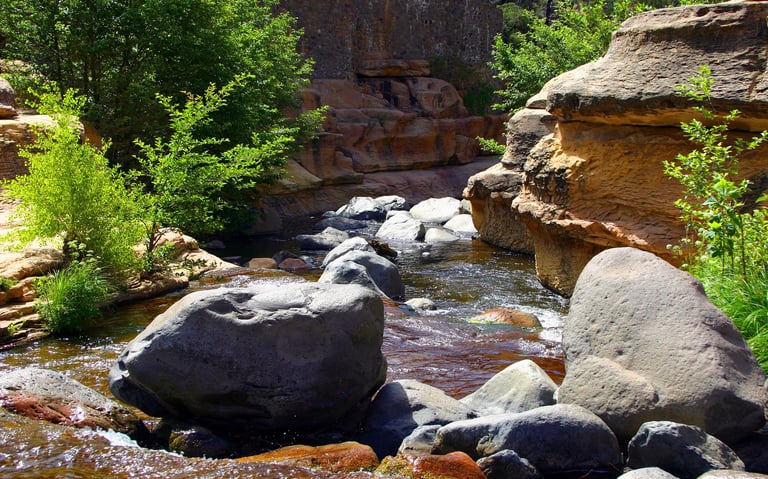
Swimming - Oak Creek provides many swim holes & beaches. Besides Slide Rock Park above, Grasshopper Point is gorgeous with deep pools and red rock cliffs you can dive off. Crescent Moon Picnic Area has several swimming holes along the less than 1 mile trail. For an awesome view of Cathedral Rock, Red Rock Crossing is good for a shallow swim & beach hangout.
Trails - Airport Mesa aka Table Top Mountain. There are several trails near the airport, but the most popular are: Airport Loop trail (3.3 miles) and Airport Mesa spur (1 mile roundtrip). The panoramic views are breathtaking.
Tlaquepaque Shopping Village - an outdoor shopping center designed as a typical Mexican village. If offers art galleries & glassware, restaurants, and other shops. And the cobblestone streets & water fountains crafted in mosaic add a romantic & charming vibe to the whole experience. Pronounced T-la-keh-pah-keh.
Night Sky Tour - Both Sedona & Flagstaff are considered “dark sky" cities - so look to the heavens & be dazzled by the wonders of the night galaxy.


Travel Tips - Sedona
Average temps high/low = Summer: 96/65 degrees F. Winter: 59/32. The hottest temperature: 113 degrees F. in 2016.
Expect snow: 1 to 10 inches of snow/yr from December thru February. Altitude: 4,360 feet.
Expect monsoons: July & August get short periods of thunderstorms & heavy rains which causes flooding. Hikers & swimmers use caution.
Backpack essentials - EXTRA water, bug spray, sunscreen, whistle, flashlight, cell phone, pocket knife, and a light jacket.
Winter Essentials - thermal blanket, waterproof boots, warm clothing.
Hiking conditions - trails can be wet & slippery, or unstable due to sliding rocks & gravel and steep terrain.
Vehicle safety – Keep a spare blanket, boots, jacket, gloves, and snacks in the car. Winter roads can be icy & snow covered: all-weather tires should be OK.
Wild animals - black bears are becoming bolder in parks/campsite areas mostly due to food. Also: big horn sheep, elk, coyotes, bobcat, and javelina.
Trash - Pack out what you pack in.
Rivers/lakes – river shoes really help on the rocky bottom. Heavy winter rains mean deep, ice-cold & fast moving water in spring.
Poison oak & ivy - always know before you touch. The common Oak has 3 leaflets per stem but can have more. Ivy always has 3 leaflets.
Poisonous snakes - 2 types, the rattlesnake & coral snake. They generally prefer to avoid humans, usually biting only if threatened. There's also poisonous scorpions, spiders, centipedes & others.
Wilderness areas – take a buddy & tell someone your travel plans.


Health & Travel Vibes
USA Based. © 2023. All rights reserved.