
Waterfall Hwy, Oregon Travel - Waterfall Hwy & Crater Lake Volcano Pt 2
Waterfall Highway 138 may be the most scenic drive in OR. It hugs the N. Umpqua River with 24 gorgeous waterfalls, like Toketee Falls. Drive thru the Cascade M:ountains to Crater Lake, the 7th deepest in the world that sits inside a volcano. Visit the spires & learn about it's mysterious past. A bucket list must.
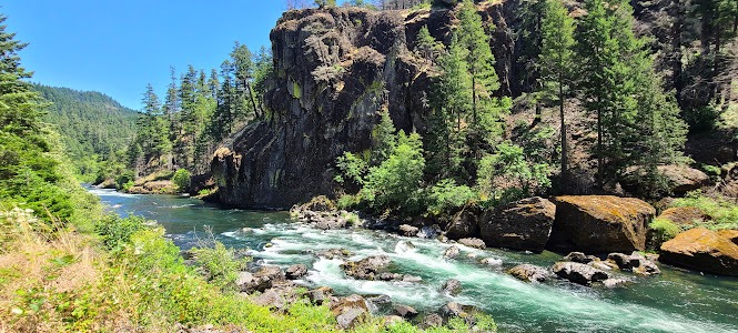
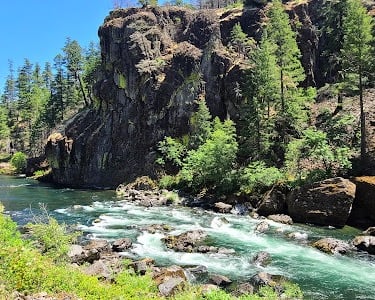
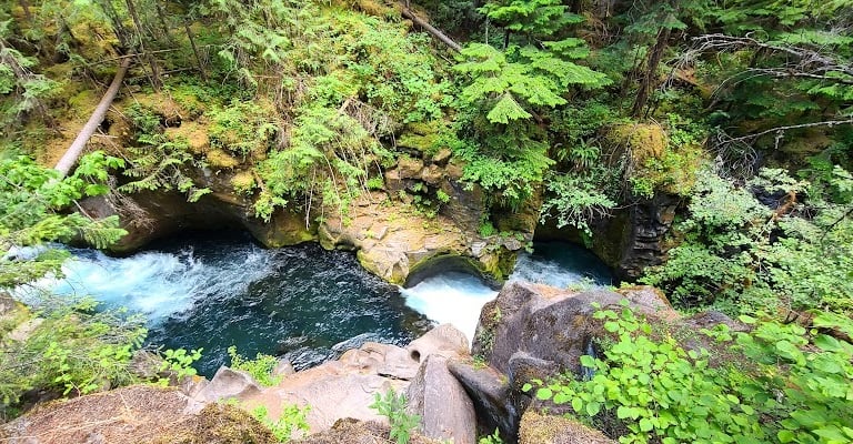
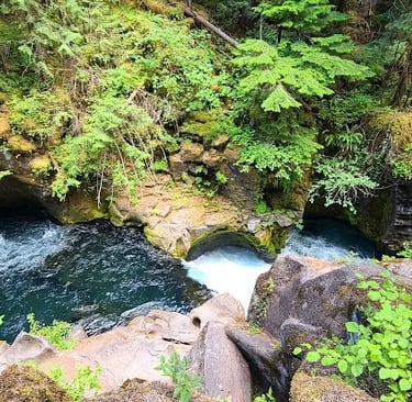
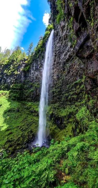
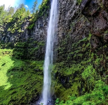
Toketee Falls
Location = Toketee Falls. 58.6 mile marker on Hwy 138, OR.
Toketee Falls is a popular waterfall and with good reason – it’s breathtaking. It’s a short .8 mile roundtrip hike. You'll want to walk a little slower than normal so you don’t miss any surprises along the way. The Toketee Falls trail is easy to moderate with some ups & downs including some stairs leading up to the viewing platform.
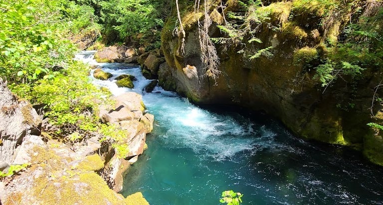
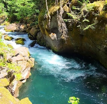
The N. Umpqua River runs alongside the trail and there's several spots with amazing views. The water is mesmerizing as it changes color from sparkling light blue to darker teal blue to emerald. The iconic Toketee Falls are widely recognized and drop 120 feet total in 2 tiers.
For an added thrill – there’s a trail that leads down to the swim hole below the falls. Just make sure you have the upper body strength to pull yourself back up the vertical climb! As for the water temperature.....well, you’re not in the Bahamas and it's fairly deep so be prepared. Compared to a hot day, it's a bit of a shocker!
OK, let's focus on Toketee Falls for a minute - photo right. Don’t get me wrong, we love finding new adventures with some thrills thrown in here & there. However, this jump is for the under 25 crowd who honestly believe they have some super power and are indestructible. No sir – if it's higher than twice my height, I won't be jumping off. End of story.
Plan 5-8 days total, Part 1-2. Total route = Interstate 5 in Roseburg, along Waterfall Hwy 138 to Crater Lake and back to Interstate 5 in Medford.
Perfect add-on trip: Wildlife Safari, Any Closer & You'd Be Lunch
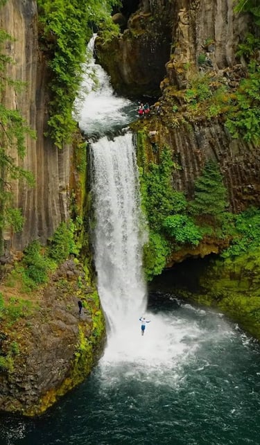
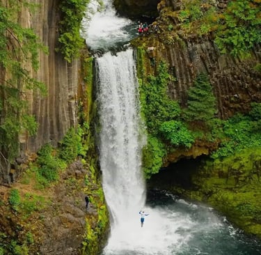
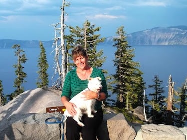
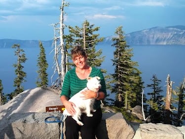
* Win a prize = Be first to email me the correct number of people in the photo above. That's some serious crazy! The real question is - where the heck is the trail to get up there?
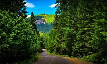
Waterfall Hwy 138, Oregon
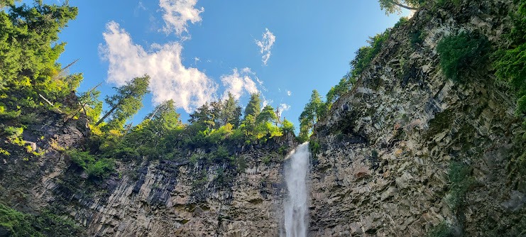
Location = Watson Falls. 61.3 mile marker on Hwy 138, OR. From 138, turn right on Forest Rd 37, drive 1/4 mile to the Ranger station & parking is .2 mile further on the right.
Watson Falls is another popular waterfall that drop 293 feet. It’s a short .8 mile loop trail that's mostly uphill. Look on the bright side - going back down is a breeze.
Watson Falls is viewable from above & below. It’s an impressive drop and the falls thunder their way down and seem to echo inside this volcanic chamber. It's easy to see that the rim is in a circular shape. I did some research to confirm - and yes, we are standing in the middle of a volcano that erupted once upon a time.
Both Toketee Falls & Watson Falls were formed by lava from vents in the earth just north of the Mt. Bailey volcano below.
Crater Lake is a super volcano. Oregon has a whopping 84 volcanoes.
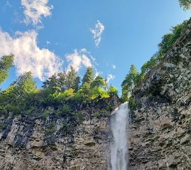
Watson Falls
There are numerous hiking trails in the area, including the mountaineer trails to the top of Mount Bailey & Mount Thielsen. Please do your research before attempting these hikes - consider both terrain & large, wild animals. They're rated strenuous.
FYI: A Recreation Pass is required for these trails due to the difficult challenges. Let us know if you hiked one of these volcanos and what amazing experiences you had.
For this trip - we're heading to Crater Lake up next.
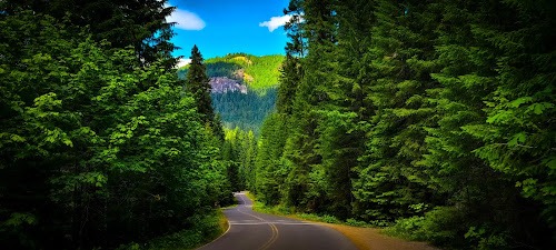
After Watson Falls, continue on Waterfall Hwy 138 - as it begins curving to the right to go south it becomes Cascade Lakes Hwy 138/245. Going past Hwy 230 on the right, it becomes Crater Lake Hwy 138. And finally Hwy 138 turns into the Cascade-Lakes Hwy, taking you past 2 more volcanoes, Mt. Bailey at 8,275 feet tall and Mt. Thielsen at 9,184 feet tall.
These volcanoes are all part of the Cascade Mountain range stretching from northern California, thru Oregon & Washington, and into southern British Columbia.
Cascade Mountains
Crater Lake National Park
Location = North Entrance
From Waterfall Hwy 138, go past Hwy 230 on the right, then right on Volcanic Legacy Scenic Byway which turns into Rim Drive. Visitor's Center is on Rim Valley Dr., as well as the Cafe, Trolley tickets, and the Lodge. FYI: Crater Lake Park requires a $30 pass per vehicle.
The North Entrance closes November 1st each year, unless heavy snowfall forces a closure sooner. It opens between mid-May to late June unless the snowfall delays it further.
Location = South Entrance
Hwy 138, go right on Hwy 230, left on Hwy 62, left on Munson Valley Rd. The Visitor's Center is on Munson Valley Rd. Rim Drive going up and around the crater is also closed during winter.
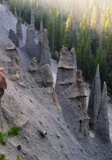
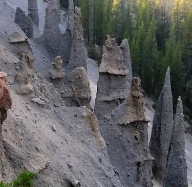
The Crater Lake Trolley is a 2 hour bus tour, that takes you along the 33 mile Rim Rd. It’s open July to mid-Sept and makes several stops for some unusual & interesting viewpoints, like the Spires photo left.
Spires are an architectural word meaning steeply pointed & elongated. Spires can rise up to 100 feet tall and are basically fossils created from gas that seeped up through hot ash & lava rocks. And I do mean HOT - like 750 degrees F. hot. Then, it cooled and hardened.
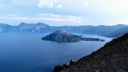
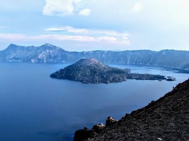
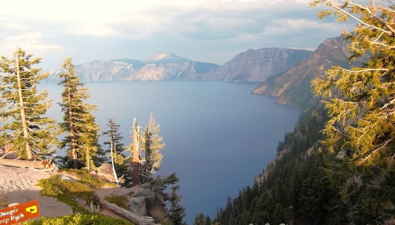
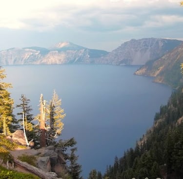
Crater Lake, Oregon
Crater Lake is the deepest lake in the USA and 7th deepest in the world – at 1,943 feet. In some places, the lake is 6 miles across. The lake is a natural wonder as it’s one of the most pristine on earth - formed only by rain water & melted snow.
The mountain surrounding Crater Lake is actually a super volcano - they say that early Native American Indians would have witnessed the massive eruption. After the mountain top collapsed inward, a huge crater was formed which then filled with water. Its also part of the Cascade Mountain range like the 2 volcanoes listed above.
Crater Lake's Mysterious Past
Crater Lake was discovered by 21 year old John Hillman in 1853, who called it Deep Blue Lake. John was a prospector looking for gold. Since then, it's developed an air of mystery. Some of it's dark history include: the still unsolved 1952 murders of 2 men, a drowning in 2024, a suicide in 1947, the still unsolved disappearance in 2006, an unsolved death in 1974 in which some clothing & bone fragments were found, and plane crashes within Crater Lake Park. Spooks-ville.
Another strange & mysterious fact: the Old Man of the Lake. The Old Man is a log that hangs about 30 feet blow the water and rises up to 4 feet above water. And....it's floating upright and not horizontally at the top of the water. A written account of Old Man was found in 1902 - that means the log has been like this for over 100 years. It was also reported in 1929 and 1938 where it was documented to have moved 3.8 miles in one day.
Some have even claimed sightings of Big Foot/Sasquatch near Annie Creek Canyon & Annie Springs. Klamath Indians also have a legend that says Llao, the god of the below world was defeated in a battle and trapped under the lake by Skell, the god of the above world. The battle was believed to have caused the eruption about 7,700 years ago. They also believe Crater Lake is a sacred place, and a place of power & danger.
Why not see Crater Lake at water level? You'll float across crystal clear waters that are a chilly 38-60 degrees F. This lakes makes me think what an itty-bitty guppy I am in this enormous fish bowl. Boat launch access is down the steep, 1 mile Cleetwood Cove Trail. FYI: Boat tours are cancelled for the 2024/2025 seasons due to repairs & rock hazards on the trail.
From Rim Drive near the Phantom Ship overlook, you can still see part of Mount Mazama - the cluster of peaks that were part of the volcano that erupted. It used to sit 12,000 feet high but the eruption reduced it's height by about 1 mile. It's now 8,157 feet high.
Each year on the 2nd + 3rd Saturdays of September, the Rim Drive is closed to vehicle traffic. Bicyclists from all over come to "Ride the Rim", a challenging and beautiful 33 mile course.
More Fun Things to Do
For Part's 1 and 2 - we've hiked to 8 waterfalls between Glide, OR and Watson Falls in Idleyld Park. That means you have tons more to explore within a 45 mile stretch of Waterfall Hwy 138 and see all 24 waterfalls within a 1 hour's drive from the highway.
There's lots of other hiking trails, including the higher elevation trails to the Mt. Bailey and Mt. Thielsen volcanoes.
Umpqua Hot Springs off the N. Umpqua River. Take NF-34 (NF = National Forest Rd) north of Waterfall Hwy 138.
Lemolo Lake and crater. Take NF-2610 north of Waterfall Hwy 138.
Diamond Lake Corrals to go horseback riding. Take NF-4795 east of Hwy 138.
Boat launch sites on the north & south shores of Diamond Lake. Take NF-4795 east of Hwy 138.
Three Lakes Sno-Park for ATV's in the summer and snowmachines in the winter. Also skiing, snowshoeing, and more. Operated by the U.S. Forest Service. An Oregon State parking permit is required. $4 for 1 day. If you have a hitch, you can rent equipment in Roseburg or Medford OR.
For lodging, there's lots campgrounds, RV sites, hotels and lodges in the area.
Vacation Travel Tips
Crater Lake Temps & Snow Warnings - Summer mountain temps are 60-80 degrees F. Winter temps average high 35, low 19. When the sun goes down, temps really drop. Winter snow is likely from Oct-Jun. FYI: Rated as the snowiest place in the USA. Average snowfall = 48 feet/yr. Nope, that’s not a typo. Check for road closures.
Average temps high/low = Summer 68/51 degrees F. Winter 53/40. Summer may get some rain. Winter rarely snows. It's usually windy, and adds a chill in winter.
There are a few places that require a “pass” or $5 cash.
Backpack essentials - water, bug spray, sunscreen, whistle, flashlight, cell phone, pocket knife, camera, and a light jacket for summer.
Winter Essentials - waterproof hiking boots, and warm clothing.
Hiking conditions - trails can be wet & slippery even in summer.
Vehicle safety – keep a spare blanket, boots, jacket, gloves, and snacks in the car. All season tires are sufficient even if it's icy a few days.
Wild animals - rarely seen on trails, but they're out there.
Trash - pack out what you pack in.
Rivers/lakes – river shoes are a must. Be mindful of currents & water temps. Heavy winter rains/snow means cold, deep & fast moving water. Most coastal cities are next to large rivers that flow into the Pacific Ocean.
Rattlesnakes - not usually found above 6,000 ft.
Wilderness areas – take a buddy & tell someone your travel plans.
Tourist season - Due to the small town coastal culture, tourist season brings heavy traffic, including motorhomes on single lane roads. Locals from inland areas also come for fishing, camping, and sand-dunes in the summer & on holidays, so parking may be limited.
Poison oak - Not on the coast, but is found 30-40 min. drive inland.
Snakes - mainly garter snakes on the coast.
Wilderness areas – take a buddy & tell someone your travel plans.

