Eugene, OR Travel - Walk the Plank High Above Rushing Waters
Love the outdoors? Walk across a log plank high above a rushing river & explore waterfalls that plunge into dazzling blue pools like Sahalie Falls & Tamolitch Falls. Visit the falls at McDowell Creek Park. Walk record holder Prefontaine's running trails along the Willamette River at Alton Baker Park.
Willamette River Loop Trail
Location = Mall access to Willamette River. 600 Valley River Center, Eugene OR. The address is to the Bowling Alley & Arcade at the back of the Mall,. Park along the river, close to the footbridge which is your starting point. The Willamette River loop trail is about 3 miles. Once across the footbridge, go left and stay on the trail closest to the river. If you feel like having a splash-fest to cool down, there's a nice little beach on the left a short distance ahead. Careful, the current is usually strong.
Next you'll pass the Rose Garden, go under the freeway, and come to a playground & restrooms. On the other side of the playground is a replica of Skinner's cabin. Eugene Skinner, the founder of Eugene originally built his cabin in 1846 on Skinner Butte, the hill see, south of the cabin. A cool side trip is half way up the hill - Skinner Butte - to see The Columns on the left. It's a nice introduction to rock climbing. Back on the trail, and next up is Lamb's Cottage & Cheshire Prairie.
Next pass the Community Center and underneath another bridge. From there you can see the footbridge to take across the Willamette River. Follow the trail along the river back to the Mall. There's so many miles of trails, you could opt for bicycles, and ride until your "seats" tired..... yep, pun intended. Now it's time to re-fuel and pick your favorite flavor and hit one of the restaurants.
Plan on spending 3-7 days. Note: The 45th parallel - halfway between the North Pole & Equator is just north of Salem (green sign on Interstate 5). The Willamette River is alive with activity from May-September.
Combine Eugene with Roseburg: Wildlife Safari, Any Closer and You'd be Lunch.
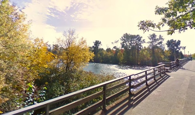
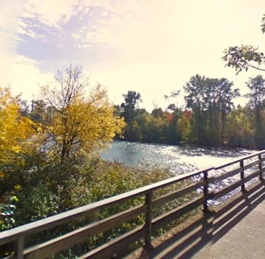
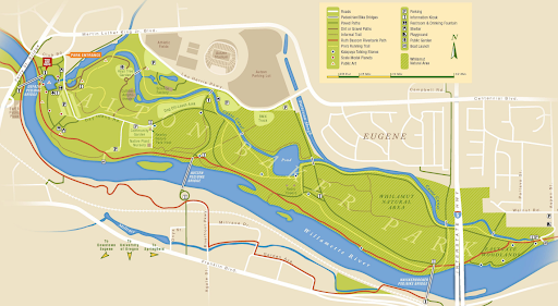
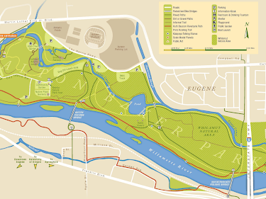
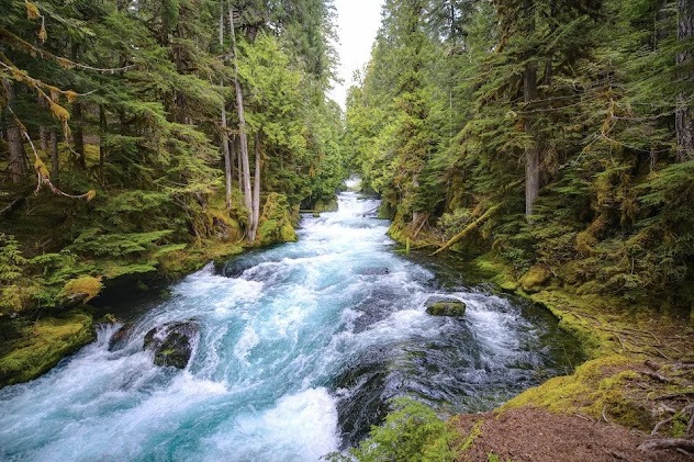
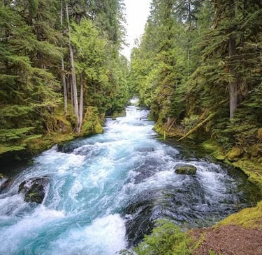
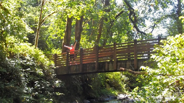
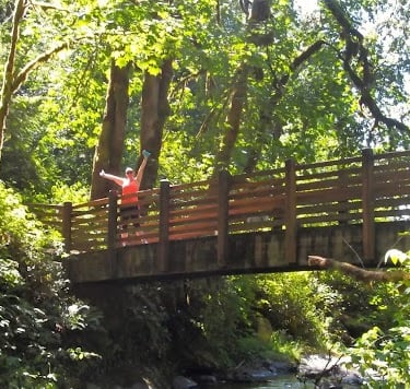
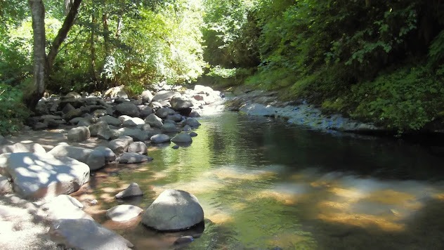
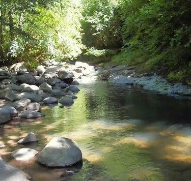
Alton Baker Park
Location = Alton Baker Park. 200 Day Island Rd, Eugene OR. Click on the map below to enlarge.
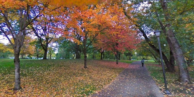
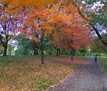
If you're an avid runner and like to keep tabs of current record holders, read obout Steve Prefontaine who was raised in Coos Bay, OR and moved to Eugene in 1969 to attend the University. To this day, he still holds the record for both the 3 mile and 6 mile run (1970 & 1973) - it's super impressive and unbelievable that nobody in 55 years has been able to beat his record. Alton Baker Park is where he often ran and you can find his exact trail - called Pre's Trail.
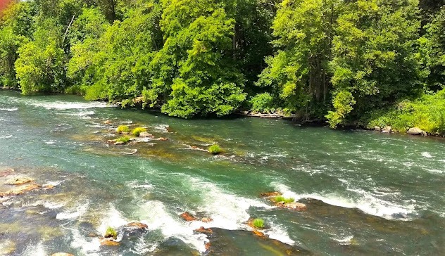
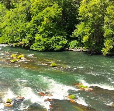
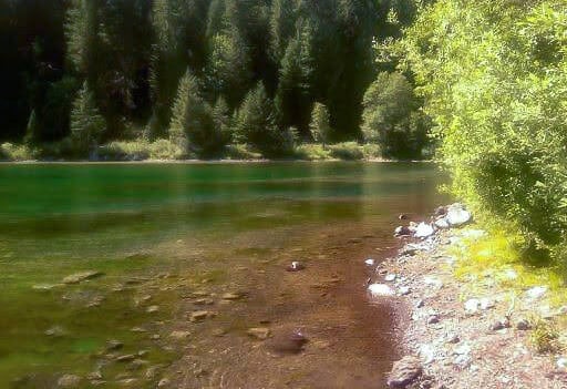
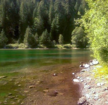
Alton Baker Park has several nice features, with plenty of terrain to walk, run, or bike. The photo below is the Willamette River from a footbridge I found along the 3.4 mile Nature Loop trail.
Eugene, Oregon
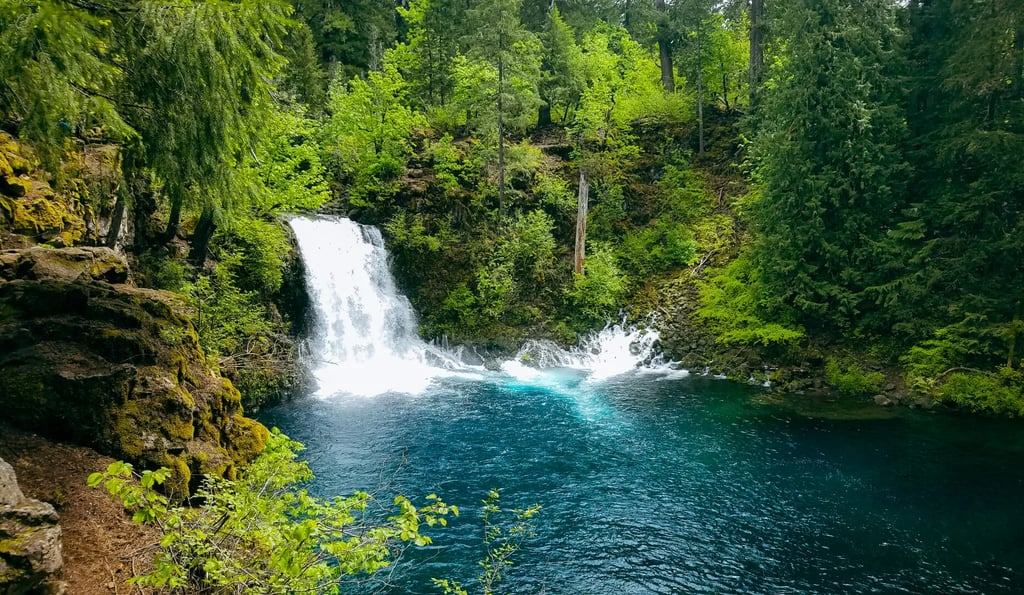
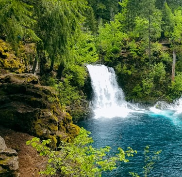
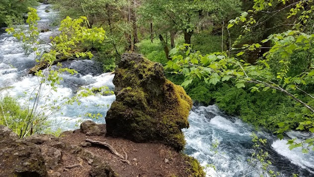
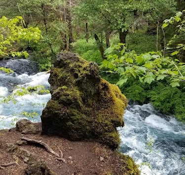
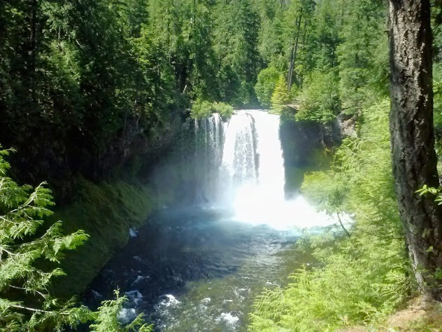
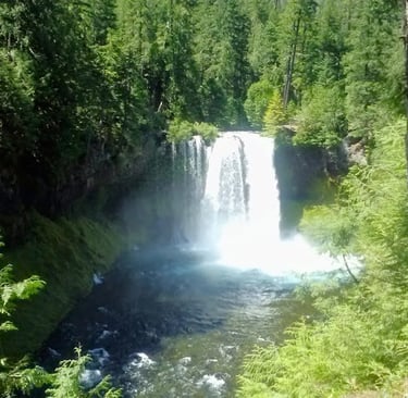
Tamolitch Falls
Tamolitch Falls is almost 4 miles roundtrip. While Tamolitch Falls is lacking in height, it makes up for in power and color. The falls plunge into a 30 foot deep, dazzling blue-turquoise pool. God's design and spectacular displays never cease to amaze! The hike to Tamolitch Falls is a fairly easy climb with several spots on the way up to view the McKenzie river.
The blue pool was created by lava from the Belknap Crater which forced the McKenzie River underground about 1,600 years ago. In rainy seasons, the river seeps back up. thru the lava bed creating the blue pool. I wouldn't recommend diving in unless you have a wetsuit with you....
FYI: The Forest Service says the average temperature of Tamolitch Falls' blue pool is 37 degrees F. Whoa baby, that's COLD. If rains were minimal during winter, the pool may be very shallow. Check with the McKenzie River Ranger Station.
From Eugene to Tamolitch Falls
Take 126 East, left on 126/Main St, drive 57 1/2 miles, left on NF-730, then stay right to Tamolitch Trail. About 68 miles east of Eugene, OR.
From Tamolitch to Sahalie Falls
Go left at the 126, drive almost 6 miles to the Koosah - Sahalie trail parking on the left. Park at Sahalie Falls as they’re viewable just off the parking lot with wheelchair access & restroom. About 72 miles east of Eugene.
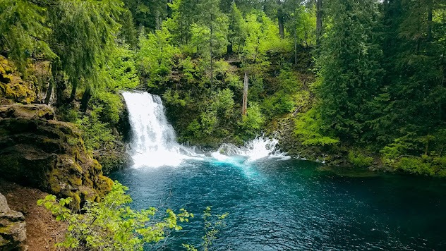
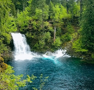
Directions: Tamolitch Falls & Sahalie Falls
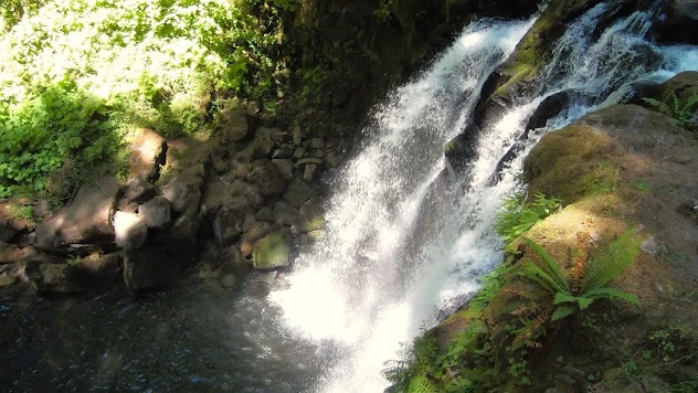
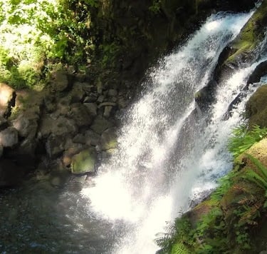
he Koosah/Sahalie Falls trail is about a 2.6 mile loop. In the Chinook Indian language - Koosah means "sky" and Sahalie means "heaven". Both waterfalls are breathtaking, however, Sahalie Falls is more impressive both in size and power. There's an equally gorgeous lake reservoir at the bottom of the loop trail. Hack to keep dogs cool: I carry an extra thermos of cool water which I pour all over their head & back to keep them cool. Half way, I'll cool them off again.
From the parking lot, head left down the gentle sloping trail where you'll see both Koosah Falls & Sahalie Falls. As you walk downhill you can spot several views of the McKenzie River in vibrant shades of blues & greens. When you get to the bottom, be prepared to be awe-struck by the lake that appears like translucent glass in a soft emerald hue - you won't be able to resist.
I invite you to wade in and enjoy the amazing water temperatures and stunning scenery. Very few places allow you to experience total tranquility such as this.
Koosah / Sahalie Falls
If you're ready - head up the trail on the other side of the McKenzie River. Interesting tidbit: Sahalie Falls are filmed in the PG movie “Homeward Bound”.
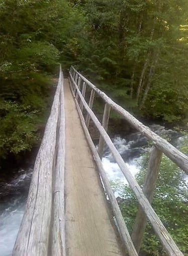
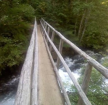
When you get to the top, you'll come to a footbridge. Wait correction.... ITS A LOG...... it’s just 1/2 of a LITTLE log. I mean the 30 inch wide walking surface really makes me feel at ease.... NOT. I cant move, I'm basically paralyzed.
Sorry, let me fill you in - I'm terrified of heights - and there's a fast moving river way down below heading straight to Sahalie Falls. OK.... time for logic & reality check. 1. Can't walk back because we're out of water. 2. The dogs are tired and it's 93 degrees F. in the sun (cooler in the woods). 3. And, the parking lot is like right over there.
Looks like I have to brave it, hopefully without peeing my pants! Kidding, I think! After verbally expressing how much this sucks, OUT Loud….. for 10 minutes straight - I finally began to tremble my way across. My daughter had to carry all 4 dogs across. Must be her super power.
Note to self: find a way to get over my fear of heights because I don't want to miss out on adventures like this. Anyone else feel my pain, and afraid of heights? See my Blog: Conquer my Fear of Heights.
Location = McDowell Creek Park. 43170 McDowell Creek Dr., Lebanon OR. It's about 53 miles NE of Eugene.
It's a short 1.6 mile loop, easy family/pet trail with 4 waterfalls. McDowell Creek Park has 3 parking options: the lower lot (west end), the middle lot & and the upper lot (east end). FYI: There's also a couple nice spots to go wading & cool off if that's your happy jam.
We parked in the lower lot and grabbed a map at the footbridge. Stop a minute on the bridge to enjoy the sparkling McDowell Creek below. First, let's take the short trail to the right to see the 20 foot Lower McDowell Falls, nothing mind blowing, but I still love the sound of falling water. Back on the main trail go almost 1/4 mile to a fork in the trail where the "loop" section begins. But, don't turn left.
We continued straight ahead, anxious to climb the stairs to see the top of Royal Terrace Falls. It's a nice 120 foot waterfall with silky smooth rocks polished by the running water. Next take the short bridge across Fall Creek, enjoying nature as you continue thru the woods and up the hill. At the "Y" intersection, stay right to begin the loop section. Soon, you'll cross McDowell Creek Drive & then the upper parking lot.
Be sure to stop at the top of Majestic falls, where you can catch a glimpse of the creek waters as they begin to plunge over the edge. Next, head down the stairs to reach the incredible view of the 40 foot falls at the bottom - living up to it's "majestic" name. FYI: there's a missing stair step, so careful. When you're ready, take the zigzag bridge across McDowell Creek.
Crystal Falls are coming up next on your left. While s only a 15 foot fall, it's fairly enticing because of the Crystal Pool at the bottom. After crossing McDowell Creek Drive (per Google maps), stay to your left when you reach the picnic area, and then over the footbridge. My 2nd favorite view is .2 miles further - all 3 tiers of Royal Terrace Falls.
Go past a trail to the right and at the intersection, go left and then right across the footbridge. Take a right to get back to the parking lot. What's your favorite of the 4 falls at McDowell Creek Park, or somewhere else?
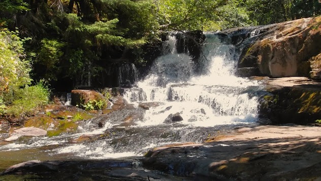
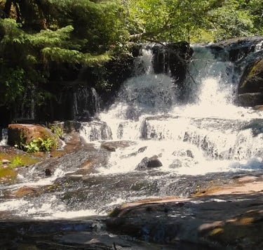
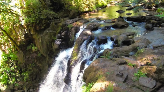
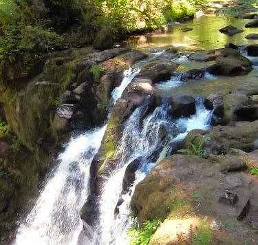
McDowell Creek Falls Park
More Fun Things to Do - Eugene
Test your skills on the Willamette River - windsurfing, kiteboarding, or an "E-Foil". That's like "Back to the Future" kind of awesome with surfboards that fly above the water.
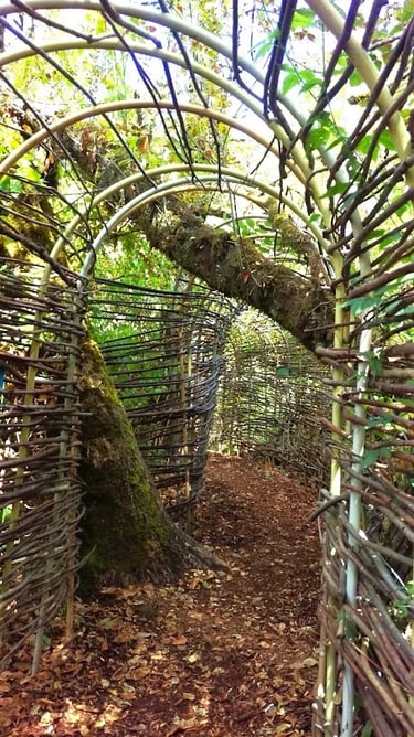
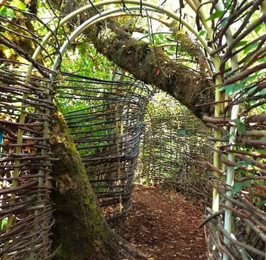
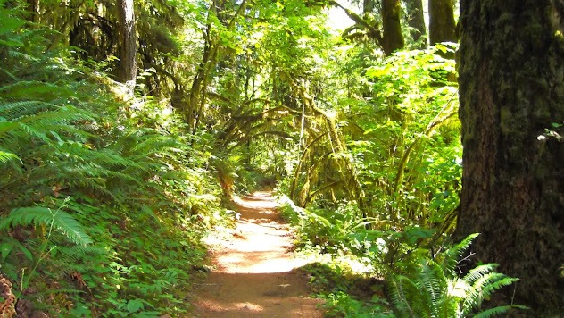
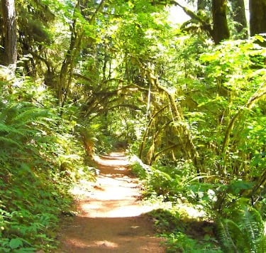
Mount Pisgah Arboretum - There are many trails offering different scenery. I've tried the Riverbank & Buford trails. See the long arch tunnel made from wood on the nature trail, next section down.
If If you love hiking, Eugene has trails galore and other worthy waterfalls like Wildwood Falls, Salt Creek Falls, and Spirit Falls.
Umpqua Hot Springs is awesome, BUT sometimes has naked bathers.
Spencer Butte has 2 trails that lead to the top for some fantastical views of the Valley & the Cascade Mountains. It’s about 2.5 miles roundtrip. The West Trail is more difficult due to its steepness.
Other popular trails include Mount Baldy, Ridgeline Trail, and Skinner Butte Park.
Owen Rose Garden, Cascades Raptor Center, or the Science Center are a few popular sites for a slower pace.


Vacation Travel Tips
Average temps high/low = Summer 84/48 degrees F. Winter 51/34. Summer can get rainy. Expect snow in some lower elevations, however, rare in the cities.
Backpack essentials - water, bug spray, sunscreen, whistle, flashlight, cell phone, pocket knife, camera, and a light jacket for summer.
Winter Essentials - thermal blanket, waterproof hiking boots, and extra warm clothing.
Hiking conditions - trails can be wet & slippery even in summer. Expect 2+ feet of snow in some lower elevations.
Vehicle safety – Keep a spare blanket, boots, jacket, gloves, and snacks in the car. Winter roads can be icy & covered in snow - use “winter” tires. FYI: If you have "all season" tires, take snow chains.
Wild animals - rarely seen on trails, but they're out there.
Trash - Pack out what you pack in.
Rivers/lakes – river shoes are a must. Heavy winter rains/snow means ice-cold, deep, & fast moving water.
Poison Oak - it grows as a vine or a shrub, and has 3 or more leaves/group.
Rattlesnakes - prefer dry/warm areas, not usually above 6,000 ft.
Wilderness areas – take a buddy & tell someone your travel plans.